
Electrical and electromagnetic methods
Electromagnetic investigation techniques are non-intrusive (and therefore indirect) methods for characterizing soils. They allow for the measurement of integrated quantities related to the distribution of electromagnetic properties in the investigated volume. These properties are mainly electrical conductivity and dielectric permittivity of the materials (magnetic permeability will be considered constant here). These properties depend on the soil's state parameters through complex relationships. For several decades, geophysicists have been working to refine and validate these laws in order to access soil parameters. As a result, the literature contains numerous models, either purely empirical or more phenomenological, attempting to replicate the electromagnetic behavior of a medium based on its porosity, water content, nature (clay content, microstructure), the ionic concentration of the imbibed water, or the volumetric fractions of the three phases present (or four phases, if free and bound water are distinguished).
Electrical resistivity techniques
The first appearances of resistivity techniques date back to the early 20th century (petroleum exploration, geological surveys, water search). Since then, applications have diversified significantly, and the scales have gradually been reduced.
Electrical resistivityρ (in Ωm) is a physical property of continuous media that expresses the ability of the medium to resist the passage of an electric current (its inverse is electrical conductivity σ, expressed in S.m-1). For a porous medium (soil, cement, concrete), this local property mainly depends on the nature of its components, its porosity, and the tortuosity of the pore space, water content, salinity of the water, and temperature. An effective measurement (over a certain volume) will therefore depend on the void index, the filling of these voids with the fluids present (saturation rate), the nature of these fluids (air, water, brine, hydrocarbons), but also on the degree of alteration of the medium. In a natural or anthropic soil, the presence of clays plays an important role in the observed phenomena.
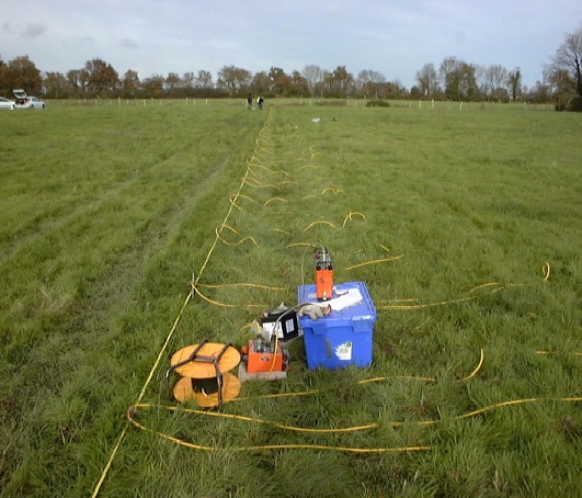
Different acquisition techniques exist: Vertical Electrical Sounding, apparent resistivity profiling (or towing), 2D Electrical Resistivity Tomography (ERT 2D, or “electrical panel”), and more generally, Electrical Resistivity Imaging techniques (2D, 3D, or 4D with temporal monitoring).
Thanks to the high sensitivity of the observables to the nature and state of the soils, as well as the great adaptability of these techniques to all spatial and temporal scales, applications cover a wide range of fields: geological reconnaissance, hydrogeology, mining exploration, natural hazards, environment (soil pollution), pedology, archaeology... Since 2005, the GeoEND laboratory has contributed, in particular, to developments related to the diagnosis and monitoring of hydraulic and protective structures.
Contact

SergioPalma-Lopes
Ingénieur, Chercheur
Co-directeur de l'équipe Géophysique et Évaluation Non Destructive (GeoEND)sergio.palma-lopes@univ-eiffel.fr
+33 (0)2 40 84 59 12Bouguenais

Electromagnetic Induction Technique
The "Slingram" technique works by electromagnetic induction using two magnetic dipoles: a transmitting loop (primary magnetic field emitted) and a receiving loop (secondary magnetic field deduced). They allow for high-efficiency profiling and mapping of apparent conductivity. At low frequencies and on not excessively conductive media (the "LIN" approximation or low induction number), the depth of investigation depends only on the distance between the two loops. Depending on their orientation (vertical, horizontal), various acquisition modes are available with different depths of investigation. Although quantitative treatments can be considered under certain assumptions (e.g., tabular medium), this technique is essentially qualitative, and the GeoEND laboratory uses it as a rapid characterization tool, complementing other monitoring techniques.
Contact
SergioPalma-Lopes
Ingénieur, Chercheur
Co-directeur de l'équipe Géophysique et Évaluation Non Destructive (GeoEND)sergio.palma-lopes@univ-eiffel.fr
+33 (0)2 40 84 59 12Bouguenais

[Translate to English:] Technique radar
The radar technique (or ground-penetrating radar, GPR) is one of the versatile monitoring techniques used in civil engineering. It can be contactless and highly efficient, with its main application related to geometric information, in the form of locating heterogeneities or measuring thicknesses. Its principle relies on studying the propagation of electromagnetic (EM) waves (usually in pulse form) and the successive reflections that can occur at each interface of the materials making up the structure/soil being monitored. The frequency bands range from hundreds of MHz for geophysical applications to a few GHz for high-frequency non-destructive testing (NDT) applications for civil engineering structures.
The radar technique is currently used as a complement in a more general research project on the study of dikes and coastal defenses through low-frequency electrical and EM techniques (PhD C. Jodry).
An older study (PhD F. Lopez, 2009) focused on the inversion of radar waveform data from multi-offsets, enabling the reconstruction of high-resolution images of buried anomalies.
Contacts

XavierDerobert
Adjoint à la direction de l'UMR Telluris (lancement été 2026)
Directeur-adjoint du laboratoire Géophysique et Evaluation Non Destructive (GéoEND)
Chercheur senior - HDRxavier.derobert@univ-eiffel.fr
+33 (0)2 40 84 59 11Bouguenais
DonatienneLeparoux
Directrice de Recherche en Géophysique
donatienne.leparoux@univ-eiffel.fr
Bouguenais
